Astro-skills used to spot supernovas and spiral galaxies will soon be deployed in disaster relief efforts to help humanitarian aid workers in Sudan.
The northeast African country endures recurring flooding which has killed hundreds of people and displaced thousands more over the last few years, leaving them homeless and with little to no food.
Scientists from Lancaster University are now preparing to roll out a new project - which has grown out of a citizen science platform - to help aid workers avoid flooded areas when delivering supplies in Sudan.
Astrophysicist Dr Brooke Simmons has been leading the humanitarian and disaster relief efforts in the Zooniverse since 2014, after realising that the skills needed to identify a new supernova are the same as those required to spot the features that are most important to responders and decision makers, such as road blockages and structural damage.
The platform gives members of the public the opportunity to help by identifying patterns in datasets that are too big for experts to examine themselves and too complex for computer algorithms and AI to label reliably.
“Humans are very good at spotting things like complex spiral patterns in galaxies, or which of the changes between nightly images of the same part of the sky have a real exploding star in them, amidst any of the other things that can change, like a satellite passing overhead or a random cosmic ray hitting the detector,” said Dr Simmons, who presented her work at this month’s National Astronomy Meeting in Hull.
“In crisis mapping you ignore changes like debris in a field that’s nowhere near a building or road, and only mark the things responders need to know about.
“The details are different, but the fundamental task is the same as in our astrophysical citizen science projects, or Zooniverse projects in other research fields.”
Now those same skills are being used to help create a map of road and riverbed crossings in Sudan, where the road network is crossed by riverbeds which flood during the rainy season.
It is very hard to predict which riverbeds will be flooded on any given day during the rainy season, which means that humanitarian workers too often have to abort a trip to deliver aid, wasting time and resources.
“Our first task in this project is to create a very thorough map of road-riverbed crossings in Sudan. We know where the roads are, but the wadi map is incomplete, so we are asking volunteers to mark the crossings and to measure the lengths of roads that are crossed by the riverbeds,” Dr Simmons said.
“That will help humanitarian workers assess how severe future flooding might be, across the whole area they are trying to bring aid to.
“That task by itself will be very valuable for aid workers. Once the rainy season gets going this year, we are hoping to use the road-riverbed map to identify areas where we can focus monitoring efforts.”
“The plan is to continue the project by asking volunteers to regularly check new imagery that’s available and see if we can rapidly identify new flooding in time to help aid workers on the ground plan their travel routes.”

The team, including Lancaster’s Humanitarian Outreach Officer Alice Mead, are working on the project with Logistics Cluster, a group of organisations coordinating the humanitarian logistics efforts in Sudan under the auspices of the United Nations World Food Programme (WFP).
“Through coordination cells in Nairobi, Port Sudan, and N’Djamena, the Logistics Cluster is providing vital logistics information management and coordination support to partner organisations,” Dr Simmons said.
“The cluster has plotted over 200 wadis on LogIE (Logistics Information Exchange) along key supply routes that are likely to be affected during the rainy season and has developed a regional map showing the estimated physical access constraints that will be faced in Sudan, Chad, and South Sudan during peak rainy season to support supply chain and access strategies.”
Mead added: “We have worked closely with Logistics Cluster to identify the key need that the Zooniverse can help them meet, and we are excited to be partnering with them.
“This is a way of enabling the public to provide vital help even if they’re far from Sudan and even if they can’t, for example, make a financial donation.”
Media contacts
Sam Tonkin
Royal Astronomical Society
Mob: +44 (0)7802 877 700
Dr Robert Massey
Royal Astronomical Society
Mob: +44 (0)7802 877 699
Science contacts
Dr Brooke Simmons
Lancaster University
Images and captions
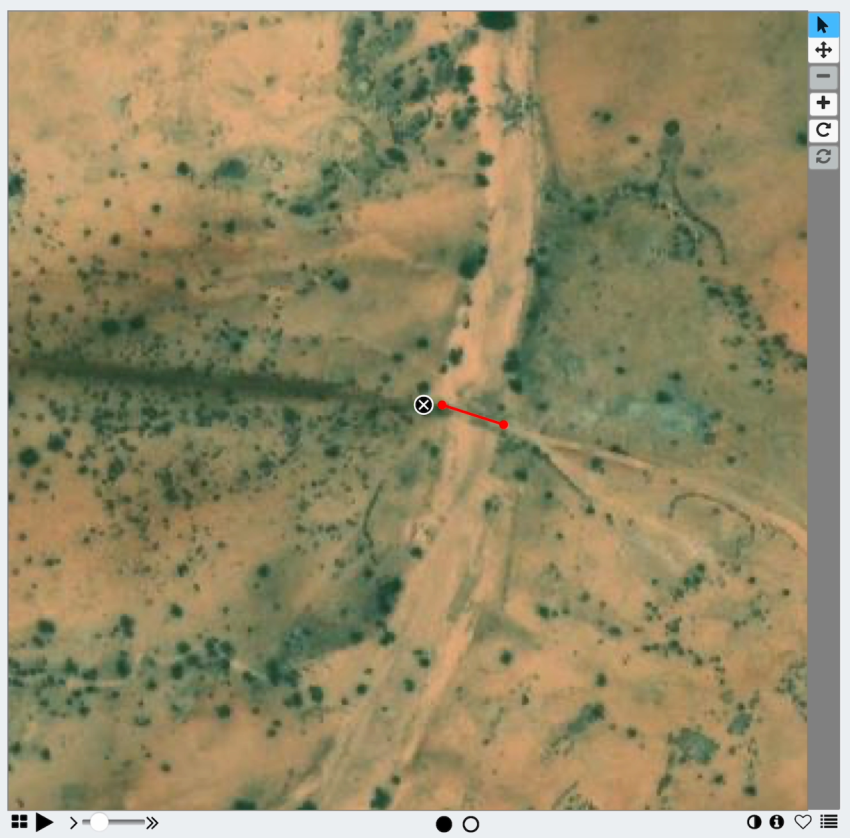
Caption: This image is an example of the task that volunteers are carrying out: finding the intersections and marking the length of road that crosses a wadi. The Zooniverse interface is what allows images to be marked.
Credit: 2024 Maxar Technologies
Caption: A satellite image showing a wadi crossing a road which can then be marked up using the markings from Zooniverse/Adler Planetarium, Chicago.
Credit: 2024 Maxar Technologies
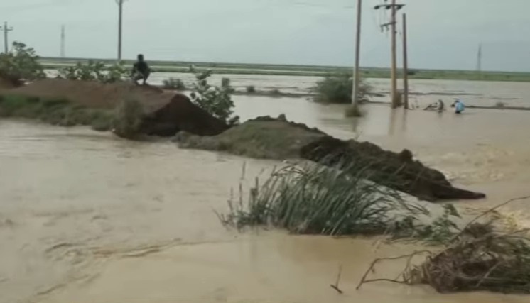
Caption: Sudan endures recurring flooding which has killed hundreds of people and displaced thousands more over the last few years, leaving them homeless and with little to no food. Pictured is heavy flooding in the northeast African country in 2022.
Credit: Ashorooq Tv
Notes for editors
The NAM 2024 conference is principally sponsored by the Royal Astronomical Society, the Science and Technology Facilities Council and the University of Hull.
About the Royal Astronomical Society
The Royal Astronomical Society (RAS), founded in 1820, encourages and promotes the study of astronomy, solar-system science, geophysics and closely related branches of science.
The RAS organises scientific meetings, publishes international research and review journals, recognises outstanding achievements by the award of medals and prizes, maintains an extensive library, supports education through grants and outreach activities and represents UK astronomy nationally and internationally. Its more than 4,000 members (Fellows), a third based overseas, include scientific researchers in universities, observatories and laboratories as well as historians of astronomy and others.
The RAS accepts papers for its journals based on the principle of peer review, in which fellow experts on the editorial boards accept the paper as worth considering. The Society issues press releases based on a similar principle, but the organisations and scientists concerned have overall responsibility for their content.
Keep up with the RAS on X, Facebook, LinkedIn and YouTube.
About the Science and Technology Facilities Council
The Science and Technology Facilities Council (STFC) is part of UK Research and Innovation – the UK body which works in partnership with universities, research organisations, businesses, charities, and government to create the best possible environment for research and innovation to flourish.
STFC funds and supports research in particle and nuclear physics, astronomy, gravitational research and astrophysics, and space science and also operates a network of five national laboratories, including the Rutherford Appleton Laboratory and the Daresbury Laboratory, as well as supporting UK research at a number of international research facilities including CERN, FERMILAB, the ESO telescopes in Chile and many more.
STFC's Astronomy and Space Science programme provides support for a wide range of facilities, research groups and individuals in order to investigate some of the highest priority questions in astrophysics, cosmology and solar system science.
STFC's astronomy and space science programme is delivered through grant funding for research activities, and also through support of technical activities at STFC's UK Astronomy Technology Centre and RAL Space at the Rutherford Appleton Laboratory. STFC also supports UK astronomy through the international European Southern Observatory and the Square Kilometre Array Organisation.
Visit https://stfc.ukri.org/ for more information. Follow STFC on Twitter: @STFC_Matters
About the University of Hull’s E.A. Milne Centre
The E.A. Milne Centre for Astrophysics at the University of Hull brings together experts who study the evolution of structure in the Universe ranging from stars through to galaxies and galaxy clusters, right up to the largest structures in the cosmos.
The centre employs observations, theory and computational methods in collaboration with international partners. Postgraduate and undergraduate students work alongside staff to understand the wonders of the Universe. Through a series of outreach activities, the centre also aims to share its passion for astronomy and astrophysics with the region and beyond.