 Outreach
Sunset strips
Published: 26 February 2016
Astronomy in the city is a lot more spectacular when the city has a street grid aligned close to east–west, as in New York.
OutreachAstronomy in the city is a lot more spectacular when the city has a street grid aligned close to east–west, as in New York.
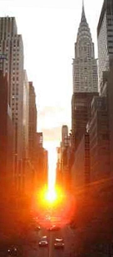
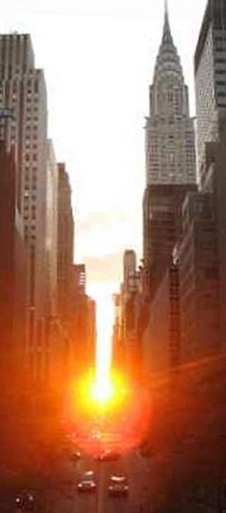
Manhattanhenge, seen on 42nd Street, 13 July 2006.
Image Credit: Wikimedia Commons/Americasroof/David Kernow
Astronomy in the city is a lot more spectacular when the city has a street grid aligned close to east–west, as in New York.
Looking at Stonehenge, it is easy to assume that it was built for astronomy in some way, because of the alignment of certain parts of the structure with the Sun at the solstices. We make no such assumptions about Manhattan, despite the uncanny alignment of its streets with the rising and setting Sun on certain dates. We know enough about the culture of 19th-century New York to be sure that factors other than the astronomical determined orientation of streets and avenues in Manhattan – yet the coincidence offers a great astronomical spectacle. It should also make us think twice before assuming too much abut those long ago builders of Stonehenge, about whom we know a lot less.
Manhattanhenge is the name given to the phenomenon in which, twice a year, the setting Sun falls along the line of Manhattan’s westward streets. The grid follows the orientation of Manhattan island, so that these streets run 29° north of west. On the two nights a year when the Sun sets on the centre line of the streets, traffic is stopped in locations such as 79th Street and people talk about suns, solstices and seasons.
Neil de Grasse Tyson, Director of the Adler Planetarium in New York, established these events as occasions for New Yorkers. Paul Murdin celebrated seeing it on 79th Street along with hundreds of New Yorkers; find out more in his 2013 A&G article.
Of course, it’s not just those streets and those nights. Sunrise also lines up on different streets on key dates, and New Jersey and Brooklyn, for example, also have grids that align with the setting Sun. If you go to NYCHenge (nychenge.com), you can see an Openstreetmap collaborative map that highlights streets that line up with the setting Sun over the calendar year.
If you would like to submit an article to A&G Forum then please go here.